 |
OSTPREUSSENHÜTTE |
(23) |
Walking Description
| Date: | 5-6-96 | Day of week: | Wednesday |
|---|
| Location: | Berchtesgadener Alps |
|---|---|
| Category: | Mountain tour |
| Starting point: | Car park "Dielalm" (Werfen) |
Ostpreussenhütte!
| Starting altitude (m): | 1016 | Highest altitude (m): | 1630 | Difference of altitude (m): | 614 |
|---|
| Characteristic: | Interesting path without any danger towards a recommendable alpine hut |
|---|---|
| Difficulty: | Easy, in the beginning steep ascent |
| Weather: | Blue sky, very warm, hazy |
| Participants: | Annemarie (32), Johanna (4), Andrea (8), Gerhard (10) und Rupert (40) |
| Time of departure (hour): | 14.20 | Time of return (hour): | 17.40 |
|---|
| Distances | Time (hours) |
Breaks (hours) |
|---|---|---|
| Car park "Dielalm" - "Blühnteggalm" | 2.05 | 0.15 |
| "Blühnteggalm" - Ostpreussenhütte | 0.40 | 0.20 |
| Total time: | 2.45 | 0.35 |
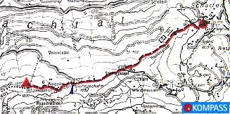
"KOMPASS" hiking map no. 15, scale:1:50 000
Map with high resolution (83 KB)
The path started at the car park directly in front of "Dielalm" and quickly reached considerable ascent, thus two thirds of the difference in altitude had already been managed when wie had only walked half of the way. Light and shade were constantly changing and all along the way grew many different alpine flowers in full bloom: Trollblume, Gold-Pippau, Stengelloser Enzian, Rote Lichtnelke, Frühlingsenzian, Vergißmeinnicht, Wundklee, Gelbe Akelei, Herzblättrige Kugelblume und Kriechender Hünsel. The higher we got, the better was our view to "Hagengebirge" and "Tennengebirge".
Especially remarkable was that Johanna managed to climb those 600 m of difference in altitude. To make this possible, drinks and food were as important as little breaks near a brook or rock.
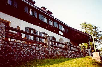
The alpine hut "Ostpreussenhütte" is situated beautifully on a rounded hilltop, in safe
surroundings near the "Hochkönigstock". It is highly recommendable, clean, tidy and its rooms are
well-proportioned. By the way, we were the only persons sleeping in the matress camp!
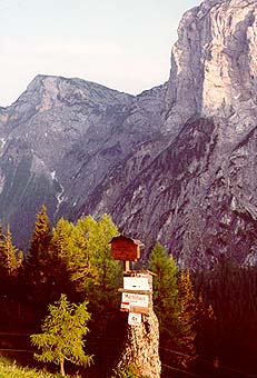 View to south (massif of Hochkönig)! |
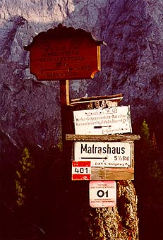 Signpost near Ostpreussenhütte! |